|
|
A walk around Monte Calvanella |
|
|
|
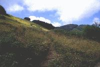
From Pian del Falco (above Sestola), one can follow the line of a disused ski-tow to the top of Monte Calvanella (1529 metres), which gives a view in all directions of the villages along the Via Giardini and the chain of mountains which divides Emilia from Tuscany. Path 449, which leads down from Monte Calvanella, runs parallel to the road to Passo del Lupo, joining it at Passo Serre. This is the starting point for path 443, which is wide for 10 minutes and then becomes narrower as it enters a vast pine wood with many juniper bushes in its undergrowth. Note the ancient retaining walls. With high meadows and rounded shapes on its North side, here to the South Monte Calvanella changes character, with many bare sedimentary rocks and wild gullies. Turning sharply to the right to avoid an old landslide, the path descends to fields and a metalled road, which in just a quarter of an hour leads to three farmhouses, their long sloping roofs still partly covered with the traditional local slate. The last of these (casa Poli) has a chapel with windows in XVII Century style and is dominated by a huge sycamore, perhaps the same age as the chapel itself. The road becomes unpaved and climbs steeply to rejoin the road from Sestola to Pian del Falco. |
|
|
|
|
© 1997 - Provincia di Modena - Made by
|
|